MP Smarter Travel has begun its second phase of consultation on proposed traffic management measures for the Queen’s Park area.
Following significant opposition to the proposals (Options A and B) amongst residents across the Ward, the survey – now termed as an “engagement” exercise and not consultation – has been extended to 6th December 2024. It is open to residents living in the Queen’s Park area or near to it i.e. Kensal Rise. Link to the survey: https://forms.monday.com/forms/380da15880e467d9465c26e7bd7bc40d?r=use1
For more information about the proposals, please click on the following link: https://www.brent.gov.uk/parking-roads-and-travel/travel-and-transport/brent-healthy-neighbourhoods/queens-park-healthy-neighbourhood
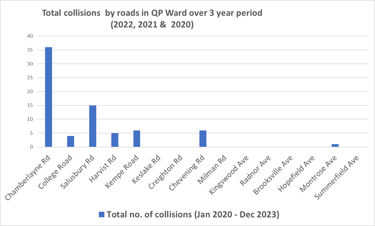
These measures are limited to roads in the Queen’s Park area. While the Kensal Rise Residents’ Association strongly advocates for healthier and safer streets for all residents in the Queen’s Park Ward, and has lobbied for years to achieve this, it is very disappointing that no measures are proposed for Chamberlayne Road, especially when the facts speak for themselves:
- Chamberlayne Road is a residential road where many residents live. From Harvist Road to Sidmouth/All Souls roundabout, Chamberlayne is actually classified as a minor road – yet thousands of residents must endure this relentless traffic
- +35 crashes and rising (2020-22) on Chamberlayne Road, making it the most dangerous road in the Queen’s Park Ward (Kensal Rise and Queen’s Park area)
- Nitrogen Dioxide (NO2) levels at Station Terrace nearly 100 µg m-3 (legal limit: 40)
- 1,100+ diesel buses and 9,000 vehicles daily on what’s technically a minor road
- Terrible Healthy Neighbourhood score for Chamberlayne Road – the lowest of the ward