Kensal Rise Residents Fight Back Against Surge in Out of Service Diesel Buses

The Kensal Rise Residents’ Association (KRRA) is leading a campaign against Transport for London (TfL) and Metroline over the routing of hundreds of empty diesel Out of Service buses through residential streets. Since Metroline took over the route 28 contract from RATP in May 2024, Out of Service buses have been diverted through Chamberlayne Road and Liddell Gardens, adding to an already congested residential area that already hosts four existing bus routes.

Initially designed for horses, carts, and Victorian-era 2ft x 4ft buses, Chamberlayne Road is owned by Brent Council of the Borough of Brent. This two-thirds residential road now faces the challenge of accommodating up to 8,000 TfL diesel buses (excluding the Out of Service buses) servicing six routes weekly, along with approximately 75,000 vehicles, including cars, vans, HGVs, lorries, and coaches, creating conditions that violate both environmental standards and residents’ fundamental rights to a safe and healthy living environment.

The controversy is heightened by TfL’s decision to specify old style diesel buses in the tender for route 28, despite the previous operator, RAPT, using electric buses and documented air quality concerns in the area. In 2018, the Mayor’s Air Quality Audit for Schools identified Ark Franklin Academy on Chamberlayne Road as among top fifty worst-polluted schools, situated on one of London’s worst polluted roads.

“It’s unacceptable that TfL would knowingly issue a tender requiring diesel buses in an area already suffering from severe air pollution,” says the Residents’ Association. The group points out that Chamberlayne Road, neither an A nor B road, now handles over 1,300 buses daily, resulting in journey times of up to 20 minutes to travel just 0.9 miles.

Residents of both Chamberlayne Road and Liddell Gardens report structural damage to their homes from constant vibrations, while the continuous convoy of empty Out of Service buses takes a circuitous two-mile route through residential streets to reach Metroline’s Willesden Junction depot, despite the availability of more suitable main road alternatives.

Conversations with route 28 drivers have revealed that Metroline’s decisions appear driven primarily by operational cost savings rather than community impact. The Residents’ Association describes this as “morally unacceptable,” noting that Metroline’s continued disregard for community wellbeing stands at odds with their responsibilities as a public transport operator.

The Residents’ Association has escalated the matter to the Local Government Ombudsman after both TfL and Metroline failed to address their concerns adequately. They are also seeking legal advice regarding compensation for property damage.

KRRA’s Response to Transport for London Consultation – Route 452 Changes

The Kensal Rise Residents’ Association (KRRA) proposes to support TfL’s proposal to change route 452 so it would operate between Vauxhall Bus Station and Notting Hill Gate, following its trial period (Proposed response at the end of this post). This position stems from the severe impact of TfL’s intensive bus operations in the neighbourhood, where over 1,100 double-decker diesel buses traverse Chamberlayne Road daily – equivalent to one bus passing residential properties every other minute, seven days a week.

The Victorian-era Chamberlayne Road, a narrow single carriageway just 6.5 metres wide, was never designed to handle such heavy traffic. The constant passage of 12-tonne buses has led to structural damage to properties, dangerous levels of air pollution, and significant safety concerns, as the road lacks the infrastructural capacity to safely accommodate such volumes – over 11,300 vehicles and 1,100 buses daily (excluding route 302). Between 2020-2022, there were 40 collisions on this road. Particularly worrying are the air quality levels near Ark Franklin Primary Academy, identified as one of London’s most polluted school locations in the Mayor’s 2018 Air Quality Audit.

Because of the intense traffic volume, bus journeys are severely impacted, often taking 20 minutes or more just to travel down Chamberlayne Road. This unreliability has made buses the least preferred travel option for many residents, who choose to drive instead to maintain control over their journey times – directly contradicting the Mayor of London’s strategy to encourage greater use of public transport.

From a broader urban planning perspective, the current bus routing appears to contradict TfL’s own stated goals of creating healthy streets and promoting active travel. The dominance of buses on Chamberlayne Road discourages cycling and walking, working against the Mayor of London’s  transport strategy of increasing active travel modes.

The KRRA notes that route 452 has already been temporarily suspended in Kensal Rise with no complaints from residents, as route 52 adequately serves the area. They propose making this change permanent. The association also recommends implementing an ANPR traffic management system to reduce cut-through traffic to improve bus journey times.

These changes would help address the community’s pressing concerns about public health, safety (particularly for cyclists and pedestrians), and quality of life while maintaining sufficient public transport access through existing routes.

If you have any feedback, please contact the KRRA by 4 PM (13 December 2024) at kensalrisera@gmail.com.

Concerns Mount Over Queen’s Park Area Healthy Neighbourhood Traffic Scheme Proposals

A wave of controversy has swept through Queen’s Park Ward (Kensal Rise and Queen’s Park area) this week following Brent Council’s launch of a consultation – quickly rebranded as a “survey” after resident backlash – regarding proposed traffic changes in just the Queen’s Park area.

The survey, for which the response deadline was also changed and extended to 6 December 2024, is being managed by MP Smarter Travel, the Council’s appointed consultants for this project.

The proposals aim to create a “healthy neighbourhood”, otherwise known as a Low Traffic Neighbourhood (LTN), through various road closures, with implementation timings to be determined through public input. See project area in the following graphic.

The Council has put forward two options (Option A and Option B) for the scheme, both of which have been criticised as draconian in nature, and absent of evidence and data-driven decision making. Under either option, residents of Kensal Rise and local businesses would be prohibited from travelling through the Queen’s Park area at certain times of the day. Meanwhile, residents of the Queen’s Park area would retain unrestricted access to Kensal Rise at all times, creating what many see as a two-tier system of access.

Alternative Queen’s Park Ward-Wide Approach

The Kensal Rise Residents’ Association (KRRA) has advocated for a more comprehensive approach, previously submitting proposals to the Council and Councillors that would reduce traffic across the entire Queen’s Park ward. Following intensive lobbying by the KRRA and recent public backlash, the Council last week announced that funding has been found to explore “congestion reduction” measures for Chamberlayne Road, with investigations to begin in early January.

However, the KRRA warns that these proposed measures may prove inadequate. With Chamberlayne Road already operating well above capacity, implementing “congestion reduction” measures alone would be futile without addressing the fundamental issue of excessive traffic volumes.

Further, as a boundary road for the proposed LTN scheme, Chamberlayne Road’s existing traffic will most likely increase due to expected traffic displacement arising from the proposed road closures. However, the Council, who hasn’t undertaken an impact assessment to understand potential traffic displacement, says this will not happen, when evidence from similar schemes implemented elsewhere in London show otherwise.

Understanding the Context

The Council’s current proposal seeks to extend existing traffic restrictions to additional roads in the Queen’s Park area, reportedly to address traffic displacement from earlier traffic restrictions implemented on some roads around the park. However, this approach has drawn significant criticism from residents across the ward.

The Chamberlayne Road Puzzle

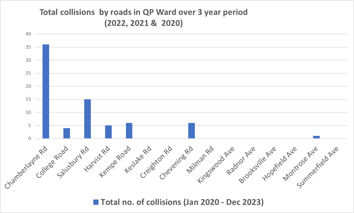
Perhaps most contentious is the notable absence of any proposals for Chamberlayne Road, despite compelling data showing it should be a priority:

– Highest collisions in the Queen’s Park Ward – 40 between 2020 and 2022

– Illegal air pollution levels, particularly affecting schools and Station Terrace residents

– Heavy traffic volumes, with 60% originating from outside Brent Borough

– Chronic issues with rat-running

Evidence vs Implementation

The KRRA, Kensal Rise residents and the local business community have expressed serious concerns about this oversight. The data presents a stark contrast: while Chamberlayne Road faces significant challenges, the Council’s focus has shifted to implementing a healthy neighbourhood scheme in the Queen’s Park area where for 99% of streets in the project coverage area:

– Air quality levels are already well below illegal limits

– Road collisions are minimal

– Traffic volumes are low

Community Division Concerns

This apparent disconnect between evidence and action has sparked intense debate across local WhatsApp groups, school gates, and street conversations. Many residents argue that this approach risks dividing the community and reinforcing perceptions of inequality within the Queen’s Park Ward, “A Ward of Two Halves”.

A Call for Evidence-Based Decision Making

As a ward funded by taxpayers’ money, decisions should be:

– Driven by data and evidence

– Transparent in their reasoning

– Aligned with values of fairness, equality, and unity

– Independent of socioeconomic influence

The growing concern is that current proposals may prioritise the voices of more privileged residents over evidence-based solutions that benefit the entire community. As this consultation process continues, residents are calling for a more equitable approach that addresses the ward’s most pressing traffic and safety issues based on clear data rather than social influence.

The Way Forward

The entire Queen’s Park ward, Chamberlayne and Salusbury roads in particular, urgently needs measures that will protect vulnerable road users – cyclists, pedestrians, and particularly schoolchildren – while creating a healthier environment and safer streets that serve the many, not just a select few.

Have Your Say.

1. **Complete Brent Council Survey by 6 December 2024** Note you have 4 options, including “Do Nothing”

https://forms.monday.com/forms/380da15880e467d9465c26e7bd7bc40d?r=use1

3. **If You Wish, Sign the Resident Led Petition Opposing the Scheme

https://bit.ly/QueensParkTrafficPetition

3. **Review Proposal Details and Map** 

 Proposed scheme / project area within purple boundary 

  https://www.brent.gov.uk/parking-roads-and-travel/travel-and-transport/brent-healthy-neighbourhoods/queens-park-healthy-neighbourhood

4. **Watch Video on Two Options** 

Option A: https://bit.ly/QueensParkTrafficPetition

Option B: https://www.youtube.com/watch?app=desktop&v=kxRIifDOuN8&feature=youtu.be

5. **Join WhatsApp Group Conversation** 

https://chat.whatsapp.com/ByCZ6dsvSnUH9sX6V7GOwX

6. **Share Feedback** 

Email: kensalrisera@gmail.com

Queen’s Park Area – Healthy Neighbourhood

MP Smarter Travel has begun its second phase of consultation on proposed traffic management measures for the Queen’s Park area.

Following significant opposition to the proposals (Options A and B) amongst residents across the Ward, the survey – now termed as an “engagement” exercise and not consultation – has been extended to 6th December 2024. It is open to residents living in the Queen’s Park area or near to it i.e. Kensal Rise. Link to the survey: https://forms.monday.com/forms/380da15880e467d9465c26e7bd7bc40d?r=use1

For more information about the proposals, please click on the following link: https://www.brent.gov.uk/parking-roads-and-travel/travel-and-transport/brent-healthy-neighbourhoods/queens-park-healthy-neighbourhood

These measures are limited to roads in the Queen’s Park area. While the Kensal Rise Residents’ Association strongly advocates for healthier and safer streets for all residents in the Queen’s Park Ward, and has lobbied for years to achieve this, it is very disappointing that no measures are proposed for Chamberlayne Road, especially when the facts speak for themselves:

  1. Chamberlayne Road is a residential road where many residents live. From Harvist Road to Sidmouth/All Souls roundabout, Chamberlayne is actually classified as a minor road – yet thousands of residents must endure this relentless traffic
  2. +35 crashes and rising (2020-22) on Chamberlayne Road, making it the most dangerous road in the Queen’s Park Ward (Kensal Rise and Queen’s Park area)
  3. Nitrogen Dioxide (NO2) levels at Station Terrace nearly 100 µg m-3 (legal limit: 40)
  4. 1,100+ diesel buses and 9,000 vehicles daily on what’s technically a minor road
  5. Terrible Healthy Neighbourhood score for Chamberlayne Road – the lowest of the ward